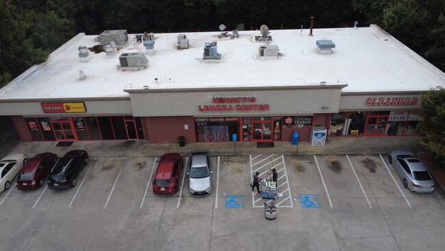
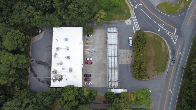
Property Record
4116 Lenora Church Rd, Snellville, GA 30039


NEARBY LISTINGS FOR SALE OR LEASE
Property Detail
4116 Lenora Church Rd
5-001-205
LENORA CHURCH ROAD
Storebuilding
Gwinnett
X
Georgia
13247C0020D
1.32 AC
2025
Lilburn/Snellville
2025
Atlanta
050737
Atlanta-Sandy Springs-Roswell, GA
7,664 SF
DEMOGRAPHICS near 4116 Lenora Church Rd
1 Mile
3 Mile
5 Mile
2024 Total Population
4,090
43,849
111,403
2029 Population
4,265
45,858
116,814
Pop Growth 2024-2029
+ 4.28%
+ 4.58%
+ 4.86%
Average Age
39
37
38
2024 Total Households
1,285
13,931
36,191
HH Growth 2024-2029
+ 4.36%
+ 4.67%
+ 4.95%
Median Household Inc
$92,885
$81,622
$79,781
Avg Household Size
3.10
3.10
3.00
2024 Avg HH Vehicles
3.00
2.00
2.00
Median Home Value
$314,942
$262,708
$259,863
Median Year Built
1994
1996
1992
Nearby Places
Map Layers
Map Styles
 Street
 Aerial
- Restaurants
- Banks
- Shops
- Fitness
- Groceries
PUBLIC TRANSPORTATION
AIRPORT
Hartsfield - Jackson Atlanta International
DRIVE
WALK
Distance
Hartsfield - Jackson Atlanta International
52 min
33.0 mi
Nearby Properties
Address
Land Use
TOTAL SIZE
Lot Size
Zoning
Address
Land Use
TOTAL SIZE
Lot Size
Zoning
162,474 SF
41 AC
R100
Address
Land Use
TOTAL SIZE
Lot Size
Zoning
175,045 SF
13.01 AC
RM
Address
Land Use
TOTAL SIZE
Lot Size
Zoning
23,692 SF
112.46 AC
RA200
Address
Land Use
TOTAL SIZE
Lot Size
Zoning
196,333 SF
23.27 AC
RS180
Address
Land Use
TOTAL SIZE
Lot Size
Zoning
217,730 SF
29.68 AC
C2
Address
Land Use
TOTAL SIZE
Lot Size
Zoning
103,821 SF
10.80 AC
M1
Address
Land Use
TOTAL SIZE
Lot Size
Zoning
151,922 SF
18.19 AC
R100
Address
Land Use
TOTAL SIZE
Lot Size
Zoning
91,096 SF
28.67 AC
OI
Address
Land Use
TOTAL SIZE
Lot Size
Zoning
90,000 SF
9.32 AC
M1
Address
Land Use
TOTAL SIZE
Lot Size
Zoning
90,151 SF
2.38 AC
C2
Address
Land Use
TOTAL SIZE
Lot Size
Zoning
57,206 SF
7 AC
C2
Address
Land Use
TOTAL SIZE
Lot Size
Zoning
350.63 AC
R100
Address
Land Use
TOTAL SIZE
Lot Size
Zoning
68,800 SF
9.01 AC
C2
Address
Land Use
TOTAL SIZE
Lot Size
Zoning
1,296 SF
65.93 AC
R100
Address
Land Use
TOTAL SIZE
Lot Size
Zoning
3,403 SF
34.69 AC
CI
Address
Land Use
TOTAL SIZE
Lot Size
Zoning
42,183 SF
11.87 AC
C2
Address
Land Use
TOTAL SIZE
Lot Size
Zoning
93,914 SF
1.56 AC
C2
Address
Land Use
TOTAL SIZE
Lot Size
Zoning
88,464 SF
8.86 AC
RM
Address
Land Use
TOTAL SIZE
Lot Size
Zoning
18,420 SF
13.92 AC
OI
Address
Land Use
TOTAL SIZE
Lot Size
Zoning
26,866 SF
8.21 AC
OI
Address
Land Use
TOTAL SIZE
Lot Size
Zoning
8,976 SF
23.21 AC
CI
Address
Land Use
TOTAL SIZE
Lot Size
Zoning
36.74 AC
R100
Address
Land Use
TOTAL SIZE
Lot Size
Zoning
38,237 SF
5.86 AC
R100
Address
Land Use
TOTAL SIZE
Lot Size
Zoning
116,970 SF
19.90 AC
C2
Address
Land Use
TOTAL SIZE
Lot Size
Zoning
36,320 SF
15.43 AC
R100
Address
Land Use
TOTAL SIZE
Lot Size
Zoning
31,434 SF
3.23 AC
C2
Address
Land Use
TOTAL SIZE
Lot Size
Zoning
22,338 SF
5.03 AC
C2
Address
Land Use
TOTAL SIZE
Lot Size
Zoning
16,950 SF
182.64 AC
R100
Address
Land Use
TOTAL SIZE
Lot Size
Zoning
16,758 SF
8.45 AC
RS180
Address
Land Use
TOTAL SIZE
Lot Size
Zoning
22,868 SF
6.30 AC
C2
The World's #1 Commercial Real Estate Marketplace
Connect with us
© 2026 CoStar Group
The information above has been obtained from sources believed reliable. While we do not doubt its accuracy we have not verified it and make no guarantee, warranty or representation about it. It is your responsibility to independently confirm its accuracy and completeness. Any projections, opinions, assumptions, or estimates used are for example only and do not represent the current or future performance of the property. The value of this transaction to you depends on tax and other factors which should be evaluated by your tax, financial, and legal advisors. You and your advisors should conduct a careful, independent investigation of the property to determine to your satisfaction the suitability of the property for your needs.